
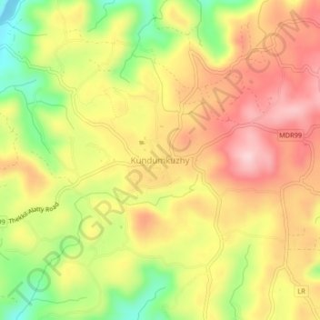
Kundumkuzhy topographic map
Interactive map
Click on the map to display elevation.
About this map
Name: Kundumkuzhy topographic map, elevation, terrain.
Average elevation: 449 ft
Minimum elevation: 16 ft
Maximum elevation: 791 ft
Other topographic maps
Click on a map to view its topography, its elevation and its terrain.
Vavadukkam
India > Kerala > Kasaragod > Bedadka
Vavadukkam, Bedadka, Kasaragod, Kasaragod District, Kerala, India
Average elevation: 436 ft
Pond at Kundamkuzhy near town
India > Kerala > Kasaragod > Kundumkuzhy
Pond at Kundamkuzhy near town, Kundumkuzhy, Kasaragod, Kasaragod District, Kerala, India
Average elevation: 479 ft