
Grimsley topographic map
Interactive map
Click on the map to display elevation.
About this map
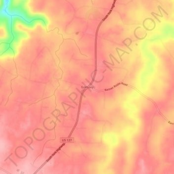
Name: Grimsley topographic map, elevation, terrain.
Average elevation: 1,696 ft
Minimum elevation: 1,394 ft
Maximum elevation: 1,788 ft
Other topographic maps
Click on a map to view its topography, its elevation and its terrain.
Allardt
United States > Tennessee > Fentress County
Allardt, Fentress County, Middle Tennessee, Tennessee, United States
Average elevation: 1,631 ft
Jamestown
United States > Tennessee > Fentress County
Jamestown, Fentress County, Middle Tennessee, Tennessee, United States
Average elevation: 1,713 ft
Banner Springs
United States > Tennessee > Fentress County
Banner Springs, Fentress County, Tennessee, United States
Average elevation: 1,667 ft
Clarkrange
United States > Tennessee > Fentress County
Clarkrange, Fentress County, Middle Tennessee, Tennessee, 38553, United States
Average elevation: 1,768 ft
Wilder
United States > Tennessee > Fentress County
Wilder, Fentress County, Middle Tennessee, Tennessee, 38589, United States
Average elevation: 1,673 ft
Pall Mall
United States > Tennessee > Fentress County
Pall Mall, Fentress County, Middle Tennessee, Tennessee, United States
Average elevation: 1,033 ft