
Emskirchen topographic map
Interactive map
Click on the map to display elevation.
About this map
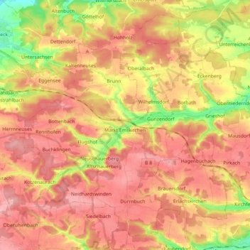
Name: Emskirchen topographic map, elevation, terrain.
Average elevation: 1,204 ft
Minimum elevation: 942 ft
Maximum elevation: 1,365 ft
Other topographic maps
Click on a map to view its topography, its elevation and its terrain.
Marktbergel
Deutschland > Bayern > Landkreis Neustadt an der Aisch-Bad Windsheim
Marktbergel, Burgbernheim (VGem), Landkreis Neustadt an der Aisch-Bad Windsheim, Bayern, 91613, Deutschland
Average elevation: 1,280 ft
Bad Windsheim
Deutschland > Bayern > Landkreis Neustadt an der Aisch-Bad Windsheim > Bad Windsheim
Bad Windsheim, Landkreis Neustadt an der Aisch-Bad Windsheim, Bayern, 91438, Deutschland
Average elevation: 1,112 ft