
Le Plane topographic map
Interactive map
Click on the map to display elevation.
About this map
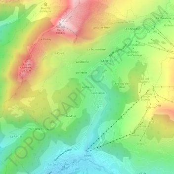
Name: Le Plane topographic map, elevation, terrain.
Average elevation: 4,426 ft
Minimum elevation: 2,972 ft
Maximum elevation: 6,545 ft
Other topographic maps
Click on a map to view its topography, its elevation and its terrain.
Le Crêt
France > Auvergne-Rhône-Alpes > Haute-Savoie > Le Grand-Bornand
Le Crêt, Le Grand-Bornand, Annecy, Haute-Savoie, Auvergne-Rhône-Alpes, France métropolitaine, 74450, France
Average elevation: 4,265 ft
La Vendanche
France > Auvergne-Rhône-Alpes > Haute-Savoie > Le Grand-Bornand
La Vendanche, Le Grand-Bornand, Annecy, Haute-Savoie, Auvergne-Rhône-Alpes, France métropolitaine, 74450, France
Average elevation: 4,596 ft