Geolocate

Dandenong Ranges topographic map

Click on the map to display elevation.

Dandenong Ranges

The topography consists of a series of ridges dissected by deeply cut streams. Sheltered gullies in the south of the range are home to temperate rain forest, fern gullies and mountain ash forest Eucalyptus regnans, whereas the drier ridges and exposed northern slopes are covered by dry sclerophyll forest of stringybarks and box. The entire range is highly prone to bushfires, the most recent of which have been the 1983 Ash Wednesday bushfires, the 1997 Dandenong Ranges bushfires and small fires during the Black Saturday bushfires in 2009.

Wikipedia (CC-BY-SA 3.0)

About this map

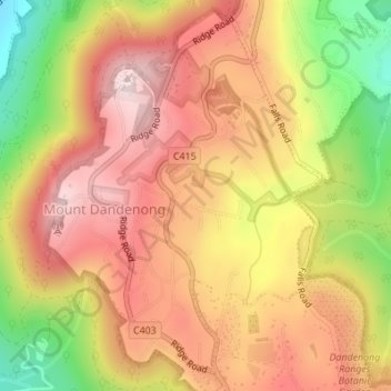
Name: Dandenong Ranges topographic map, elevation, terrain.

Location: Dandenong Ranges, Melbourne, Shire of Yarra Ranges, Victoria, 3767, Australia (-37.83532 145.35890 -37.83522 145.35900)

Average elevation: 1,496 ft

Minimum elevation: 699 ft

Maximum elevation: 2,037 ft

Other topographic maps

Click on a map to view its topography, its elevation and its terrain.

Warrandyte District

Australia > Victoria > Melbourne

Average elevation: 335 ft

Portsea

Australia > Victoria > Melbourne

Average elevation: 20 ft

Ivanhoe East

Australia > Victoria > Melbourne

Average elevation: 105 ft

Point Cook

Australia > Victoria > Melbourne

Average elevation: 26 ft

Elwood

Australia > Victoria > Melbourne

Average elevation: 26 ft

Yarra Bend Park

Australia > Victoria > Melbourne

Average elevation: 102 ft

East Melbourne

Australia > Victoria > Melbourne

Average elevation: 79 ft

Plenty Gorge Park

Australia > Victoria > Melbourne

Average elevation: 469 ft

Hawthorn

Australia > Victoria > Melbourne

Average elevation: 108 ft

Kew

Australia > Victoria > Melbourne

Average elevation: 125 ft

Belgrave

Australia > Victoria > Melbourne > Belgrave

Average elevation: 722 ft

Northcote District

Australia > Victoria > Melbourne

Average elevation: 144 ft

Emerald

Australia > Victoria > Melbourne

Average elevation: 738 ft

Mornington District

Australia > Victoria > Melbourne

Average elevation: 164 ft

Langwarrin

Australia > Victoria > Melbourne

Average elevation: 233 ft

Rosebud

Australia > Victoria > Melbourne

Average elevation: 144 ft

Dights Falls

Australia > Victoria > Melbourne

Average elevation: 92 ft

Coburg North

Australia > Victoria > Melbourne

Average elevation: 220 ft

Bayswater North

Australia > Victoria > Melbourne

Average elevation: 377 ft

Wantirna South

Australia > Victoria > Melbourne

Average elevation: 272 ft

Port Melbourne

Australia > Victoria > Melbourne

Average elevation: 13 ft

Brunswick

Australia > Victoria > Melbourne

Average elevation: 161 ft

Greenvale

Australia > Victoria > Melbourne

Average elevation: 535 ft

Sunshine

Australia > Victoria > Melbourne

Average elevation: 121 ft

Main Ridge

Australia > Victoria > Melbourne

Average elevation: 541 ft

Mount Eliza

Australia > Victoria > Melbourne

Average elevation: 197 ft

Moonee Ponds

Australia > Victoria > Melbourne > Moonee Ponds

Average elevation: 98 ft

Hawthorn East

Australia > Victoria > Melbourne

Average elevation: 161 ft

Elwood Canal

Australia > Victoria > Melbourne

Average elevation: 20 ft

Yarra River

Australia > Victoria > Melbourne > McMahons Creek

Average elevation: 951 ft

Gladysdale

Australia > Victoria > Melbourne

Average elevation: 892 ft

Narre Warren South

Australia > Victoria > Melbourne

Average elevation: 108 ft

Dandenong South

Australia > Victoria > Melbourne

Average elevation: 59 ft

Melton District

Australia > Victoria > Melbourne

Average elevation: 469 ft

Fitzroy

Australia > Victoria > Melbourne

Fitzroy's topography is flat. It is laid out in grid plan and is characterised by a fairly tightly spaced rectangular grid of medium-sized streets, with many of its narrow streets and back lanes facilitating only one-way traffic. Its built form is a legacy of its early history when a mixture of land uses was…

Average elevation: 115 ft

Steels Creek

Australia > Victoria > Melbourne

Average elevation: 781 ft

Jack Edwards Reserve

Australia > Victoria > Melbourne

Average elevation: 226 ft

Shire Hall Beach

Australia > Victoria > Melbourne

Average elevation: 49 ft

Nangana

Australia > Victoria > Melbourne

Average elevation: 502 ft

Shoalhaven Street Park

Australia > Victoria > Melbourne

Average elevation: 92 ft

Croydon South

Australia > Victoria > Melbourne

Average elevation: 387 ft

St Albans

Australia > Victoria > Melbourne

Average elevation: 210 ft

Oysterbay Chase Park

Australia > Victoria > Melbourne

Average elevation: 16 ft

Valley Reserve

Australia > Victoria > Melbourne

Average elevation: 351 ft

Coburg Lake Reserve

Australia > Victoria > Melbourne

Average elevation: 207 ft

Pentridge Piazza

Australia > Victoria > Melbourne

Average elevation: 200 ft

Koo Wee Rup

Australia > Victoria > Melbourne

Average elevation: 20 ft

Ashburton

Australia > Victoria > Melbourne

Average elevation: 161 ft

Pascoe Vale District

Australia > Victoria > Melbourne

Average elevation: 240 ft

West Melbourne

Australia > Victoria > Melbourne

Average elevation: 26 ft

Altona North

Australia > Victoria > Melbourne

Average elevation: 49 ft

Newport

Australia > Victoria > Melbourne

Average elevation: 36 ft

Beaumaris

Australia > Victoria > Melbourne

Average elevation: 62 ft

Balwyn North

Australia > Victoria > Melbourne

Average elevation: 167 ft

Hillside

Australia > Victoria > Melbourne

Average elevation: 440 ft

Keilor

Australia > Victoria > Melbourne

Average elevation: 236 ft

Keilor East

Australia > Victoria > Melbourne

Average elevation: 180 ft

Tullamarine

Australia > Victoria > Melbourne

Average elevation: 295 ft

Bentleigh East

Australia > Victoria > Melbourne

Average elevation: 164 ft

St Kilda East

Australia > Victoria > Melbourne

Average elevation: 89 ft

Clayton

Australia > Victoria > Melbourne

Average elevation: 259 ft

Dingley Village

Australia > Victoria > Melbourne

Average elevation: 85 ft

Melton South

Australia > Victoria > Melbourne

Average elevation: 394 ft

Boronia

Australia > Victoria > Melbourne

Average elevation: 453 ft

Knoxfield

Australia > Victoria > Melbourne

Average elevation: 262 ft

Rowville

Australia > Victoria > Melbourne

Average elevation: 259 ft

Broadmeadows

Australia > Victoria > Melbourne

Average elevation: 381 ft

Roxburgh Park

Australia > Victoria > Melbourne

Average elevation: 591 ft

Springvale

Australia > Victoria > Melbourne > Springvale

Average elevation: 200 ft

Fitzroy North

Australia > Victoria > Melbourne

Average elevation: 125 ft

Cockatoo

Australia > Victoria > Melbourne

Average elevation: 761 ft

Truganina

Australia > Victoria > Melbourne

Average elevation: 187 ft

Olinda

Australia > Victoria > Melbourne

Average elevation: 1,214 ft

Sunbury

Australia > Victoria > Melbourne

Average elevation: 902 ft

Richmond

Australia > Victoria > Melbourne

Average elevation: 62 ft

Box Hill District

Australia > Victoria > Melbourne > Blackburn

Average elevation: 289 ft

Gembrook District

Australia > Victoria > Melbourne

Average elevation: 545 ft

Vermont South

Australia > Victoria > Melbourne

In 1966 the Metropolitan & Melbourne Board of Works (MMBW) put forth a plan to construct numerous "package" sewage treatment plants in the valleys of Dandenong Creek and its tributaries. The project aimed to provide adequate sewerage to the catchment before the Dandenong Valley Trunk sewer (DVT) could…

Average elevation: 328 ft

Chirnside Park

Australia > Victoria > Melbourne

Average elevation: 335 ft

Mount Dandenong

Australia > Victoria > Melbourne

Mount Dandenong has an oceanic climate (Cfb) with warm summers and cool winters. The temperature usually is 3 - 7 °C (5.4 - 12.6 °F) cooler than downtown Melbourne due to its elevation and distance from the urban island heating effect of Melbourne.

Average elevation: 1,339 ft

South Melbourne

Australia > Victoria > Melbourne

Average elevation: 30 ft

Park Orchards

Australia > Victoria > Melbourne

Average elevation: 374 ft

Pakenham

Australia > Victoria > Melbourne

Average elevation: 184 ft

Coldstream

Australia > Victoria > Melbourne

Average elevation: 397 ft

Albert Park District

Australia > Victoria > Melbourne

Average elevation: 33 ft

Abbotsford

Australia > Victoria > Melbourne

Average elevation: 82 ft

Surrey Hills

Australia > Victoria > Melbourne

Average elevation: 315 ft

The Basin

Australia > Victoria > Melbourne

Average elevation: 755 ft

Scoresby

Australia > Victoria > Melbourne

Scoresby has a weather station which collects data for the Bureau of Meteorology. It commenced readings in 1948 and is situated at Latitude 37.87°S and Longitude 145.26°E at an elevation of 80m above sea level. The site name is the Scoresby Research Institute and its site number is 086104, however it is not…

Average elevation: 203 ft

Heidelberg

Australia > Victoria > Melbourne

Average elevation: 161 ft

Cranbourne District

Australia > Victoria > Melbourne

Average elevation: 131 ft

Southbank

Australia > Victoria > Melbourne

Average elevation: 52 ft

Montmorency

Australia > Victoria > Melbourne

Average elevation: 210 ft

Templestowe

Australia > Victoria > Melbourne

Gentle, rolling hills extend from east of the Yarra River flood plains, along Templestowe Road (towards the Eastern Freeway) for seven km (4.3 miles), to the north-east. The altitude of the plain above sea level is 50 m, and the topography is subdued and mostly flat; the hills are just below 60 m, the slopes…

Average elevation: 217 ft

Kalkallo

Australia > Victoria > Melbourne

Average elevation: 768 ft

Ringwood East

Australia > Victoria > Melbourne

Average elevation: 449 ft

Seaford

Australia > Victoria > Melbourne

Average elevation: 30 ft

Montrose

Australia > Victoria > Melbourne

Montrose varies in altitude from about 91 m to 324 m above sea level. Montrose covers an area of 11 square kilometres (2,700 acres).

Average elevation: 771 ft

Gear up for your next adventure:

🛠️Backpacking Tool Kit - Essential toolkit for outdoor repairs
🛡️Bear Spray Outdoor - Protection in bear country hikes
🔥Fast-Boil Camping Stoves - Efficient cooking systems for quick trail meals
📱Heavy-Duty Phone Cases - Drop-proof and waterproof protection for outdoor navigation
🧢Sun Protection Hats - Wide-brimmed and UPF-rated hats for high-altitude sun safety

As an Amazon Associate, this site earns from qualifying purchases at no extra cost to you.