
Parsberg topographic map
Click on the map to display elevation.
About this map
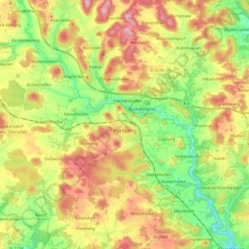
Name: Parsberg topographic map, elevation, terrain.
Average elevation: 1,686 ft
Minimum elevation: 1,365 ft
Maximum elevation: 2,077 ft
Other topographic maps
Click on a map to view its topography, its elevation and its terrain.
St. Wolfgang
Germany > Bavaria > Landkreis Neumarkt in der Oberpfalz > Dantersdorf
Average elevation: 1,798 ft
Großbissendorf
Germany > Bavaria > Landkreis Neumarkt in der Oberpfalz > Großbissendorf
Average elevation: 1,614 ft