
Bagnols-les-Bains topographic map
Interactive map
Click on the map to display elevation.
About this map
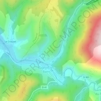
Name: Bagnols-les-Bains topographic map, elevation, terrain.
Average elevation: 3,350 ft
Minimum elevation: 2,917 ft
Maximum elevation: 4,196 ft
Other topographic maps
Click on a map to view its topography, its elevation and its terrain.
Mont Lozère et Goulet
France > Occitanie > Mont Lozère et Goulet
Mont Lozère et Goulet, Mende, Lozère, Occitanie, France métropolitaine, 48190, France
Average elevation: 4,045 ft