
Make a donation
Gear up for your next adventure:
As an Amazon Associate, this site earns from qualifying purchases at no extra cost to you.
Santeramo in Colle topographic map
Click on the map to display elevation.
Make a donation
Gear up for your next adventure:
As an Amazon Associate, this site earns from qualifying purchases at no extra cost to you.
Santeramo in Colle
By altitude, Santeramo in Colle is the highest municipality in the metropolitan city of Bari.
Make a donation
Gear up for your next adventure:
As an Amazon Associate, this site earns from qualifying purchases at no extra cost to you.
About this map
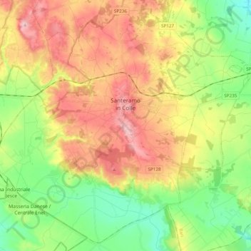
Name: Santeramo in Colle topographic map, elevation, terrain.
Location: Santeramo in Colle, Bari, Apulia, 70029, Italy (40.71177 16.65600 40.84878 16.84975)
Average elevation: 1,371 ft
Minimum elevation: 1,096 ft
Maximum elevation: 1,703 ft
Make a donation
Gear up for your next adventure:
As an Amazon Associate, this site earns from qualifying purchases at no extra cost to you.
Other topographic maps
Click on a map to view its topography, its elevation and its terrain.