
Northern District topographic map
Interactive map
Click on the map to display elevation.
About this map
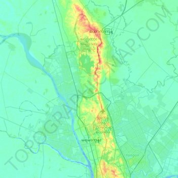
Name: Northern District topographic map, elevation, terrain.
Location: Northern District, Yangon, Myanmar (16.80460 95.99476 17.09075 96.18454)
Average elevation: 26 ft
Minimum elevation: -10 ft
Maximum elevation: 164 ft
Other topographic maps
Click on a map to view its topography, its elevation and its terrain.
North Okkalapa
North Okkalapa, Yangon East, Yangon, Myanmar
Average elevation: 33 ft
Mingaladon
Mingaladon, Yangon, Yangon North, Yangon, Myanmar
Average elevation: 33 ft