
Make a donation
Gear up for your next adventure:
As an Amazon Associate, this site earns from qualifying purchases at no extra cost to you.
Rahden topographic map
Click on the map to display elevation.
Make a donation
Gear up for your next adventure:
As an Amazon Associate, this site earns from qualifying purchases at no extra cost to you.
About this map
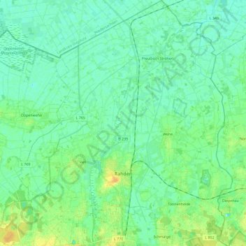
Name: Rahden topographic map, elevation, terrain.
Average elevation: 138 ft
Minimum elevation: 115 ft
Maximum elevation: 194 ft
Make a donation
Gear up for your next adventure:
As an Amazon Associate, this site earns from qualifying purchases at no extra cost to you.
Other topographic maps
Click on a map to view its topography, its elevation and its terrain.
Reineberg
Germany > North Rhine-Westphalia > Kreis Minden-Lübbecke > Lübbecke
The Reineberg is a hill on the Wiehen ridge, south of the town of Lübbecke. With a height of 275.9 m above sea level it is, from a topographical point of view, not a particularly impressive eminence in this part of the Wiehen Hills, because, in the immediate vicinity are considerably higher summits, such as…
Average elevation: 594 ft
Heimsen
Germany > North Rhine-Westphalia > Kreis Minden-Lübbecke > Petershagen
Average elevation: 135 ft
Hüllhorst
Germany > North Rhine-Westphalia > Kreis Minden-Lübbecke > Hüllhorst > Hüllhorst
Average elevation: 394 ft
Lübbecke
Germany > North Rhine-Westphalia > Kreis Minden-Lübbecke > Lübbecke > Lübbecke
Average elevation: 361 ft
Make a donation
Gear up for your next adventure:
As an Amazon Associate, this site earns from qualifying purchases at no extra cost to you.