
Morton Island topographic map
Interactive map
Click on the map to display elevation.
About this map
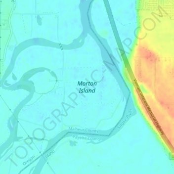
Name: Morton Island topographic map, elevation, terrain.
Average elevation: 2,169 ft
Minimum elevation: 2,139 ft
Maximum elevation: 2,270 ft
Other topographic maps
Click on a map to view its topography, its elevation and its terrain.
Boring
United States of America > Oregon > Boring
Boring, Clackamas County, Oregon, 97009, United States of America
Average elevation: 600 ft
Rhododendron
United States of America > Oregon > Rhododendron
Rhododendron, The Villages at Mount Hood, Clackamas County, Oregon, 97049, United States of America
Average elevation: 2,411 ft
Iron Knob
United States of America > Oregon
Iron Knob, Jackson County, Oregon, United States of America
Average elevation: 2,825 ft
Wemme
United States of America > Oregon > Wemme
Wemme, The Villages at Mount Hood, Clackamas County, Oregon, 97067, United States of America
Average elevation: 1,621 ft
Barlow
United States of America > Oregon > Barlow
Barlow, Clackamas County, Oregon, United States of America
Average elevation: 102 ft
Lake County
United States of America > Oregon
Lake County, Oregon, United States of America
Average elevation: 5,052 ft
McKenzie River
United States of America > Oregon
McKenzie River, Lane County, Oregon, 97413, United States of America
Average elevation: 1,414 ft
Hillsboro
United States of America > Oregon > Hillsboro
Hillsboro, Washington County, Oregon, United States of America
Average elevation: 174 ft
Hail Creek
United States of America > Oregon
Hail Creek, Crook County, Oregon, United States of America
Average elevation: 4,633 ft