
Bride topographic map
Interactive map
Click on the map to display elevation.
About this map
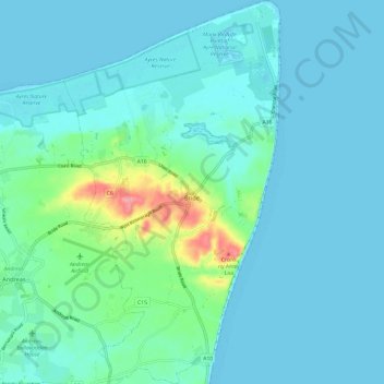
Name: Bride topographic map, elevation, terrain.
Location: Bride, Ayre, Isle of Man (54.34821 -4.42910 54.41799 -4.36111)
Average elevation: 46 ft
Minimum elevation: -3 ft
Maximum elevation: 312 ft
Other topographic maps
Click on a map to view its topography, its elevation and its terrain.
Yellow Stone
Isle of Man > Ayre > Lezayre
Yellow Stone, Lezayre, Ayre, Isle of Man
Average elevation: 1,335 ft