
Thank you for supporting this site ❤️
Make a donation
Make a donation
Gear up for your next adventure:
As an Amazon Associate, this site earns from qualifying purchases at no extra cost to you.
Bierbeek topographic map
Click on the map to display elevation.
Thank you for supporting this site ❤️
Make a donation
Make a donation
Gear up for your next adventure:
As an Amazon Associate, this site earns from qualifying purchases at no extra cost to you.
About this map
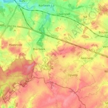
Name: Bierbeek topographic map, elevation, terrain.
Location: Bierbeek, Leuven, Flemish Brabant, 3360, Belgium (50.78809 4.69112 50.86017 4.81579)
Average elevation: 243 ft
Minimum elevation: 85 ft
Maximum elevation: 361 ft
Thank you for supporting this site ❤️
Make a donation
Make a donation
Gear up for your next adventure:
As an Amazon Associate, this site earns from qualifying purchases at no extra cost to you.