
Bournemouth topographic map
Interactive map
Click on the map to display elevation.
About this map
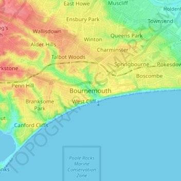
Name: Bournemouth topographic map, elevation, terrain.
Average elevation: 69 ft
Minimum elevation: 0 ft
Maximum elevation: 223 ft
Other topographic maps
Click on a map to view its topography, its elevation and its terrain.
Bournemouth
United Kingdom > England > Bournemouth, Christchurch and Poole > Wick
Bournemouth, Wick, Bournemouth, Christchurch and Poole, England, United Kingdom
Average elevation: 56 ft
Merley
United Kingdom > England > Bournemouth, Christchurch and Poole
Merley, Bournemouth, Christchurch and Poole, England, BH21 3AQ, United Kingdom
Average elevation: 112 ft
Poole
United Kingdom > England > Bournemouth, Christchurch and Poole > Merley
Poole, Merley, Bournemouth, Christchurch and Poole, England, United Kingdom
Average elevation: 75 ft
Kinson
United Kingdom > England > Bournemouth, Christchurch and Poole > Kinson
Kinson, Bournemouth, Christchurch and Poole, South West England, England, BH10 7AY, United Kingdom
Average elevation: 85 ft
Talbot Village
United Kingdom > England > Bournemouth, Christchurch and Poole > Talbot Village
Talbot Village, Bournemouth, Christchurch and Poole, South West England, England, BH10 4JA, United Kingdom
Average elevation: 131 ft
Poole
United Kingdom > England > Bournemouth, Christchurch and Poole
Poole, Bournemouth, Christchurch and Poole, England, BH15 1SU, United Kingdom
Average elevation: 52 ft
Highcliffe-on-Sea
United Kingdom > England > Bournemouth, Christchurch and Poole
Highcliffe-on-Sea, Bournemouth, Christchurch and Poole, England, BH23 5JN, United Kingdom
Average elevation: 62 ft