
Cassagnettes topographic map
Interactive map
Click on the map to display elevation.
About this map
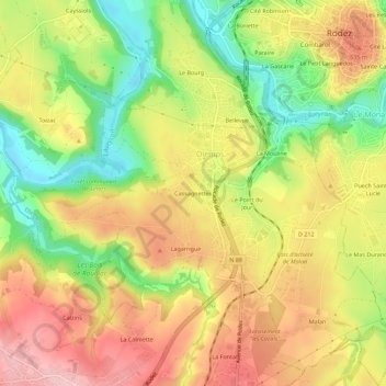
Name: Cassagnettes topographic map, elevation, terrain.
Average elevation: 1,959 ft
Minimum elevation: 1,644 ft
Maximum elevation: 2,234 ft
Other topographic maps
Click on a map to view its topography, its elevation and its terrain.
Le Point du Jour
France > Occitanie > Aveyron > Olemps
Le Point du Jour, Olemps, Rodez, Aveyron, Occitanie, France métropolitaine, 12510, France
Average elevation: 1,955 ft