
Churchstow topographic map
Interactive map
Click on the map to display elevation.
About this map
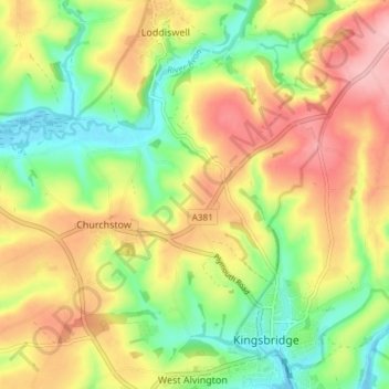
Name: Churchstow topographic map, elevation, terrain.
Average elevation: 240 ft
Minimum elevation: -16 ft
Maximum elevation: 509 ft
Other topographic maps
Click on a map to view its topography, its elevation and its terrain.
Staverton
United Kingdom > England > South Hams
Staverton, South Hams, Devon, South West England, England, United Kingdom
Average elevation: 259 ft
Snowdon
United Kingdom > England > South Hams
Snowdon, South Hams, Devon, South West England, England, TQ11 0JQ, United Kingdom
Average elevation: 1,407 ft