
Rugeley topographic map
Interactive map
Click on the map to display elevation.
About this map
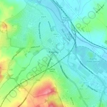
Name: Rugeley topographic map, elevation, terrain.
Location: Rugeley, Cannock Chase, Staffordshire, England, United Kingdom (52.74271 -1.96820 52.77418 -1.92549)
Average elevation: 295 ft
Minimum elevation: 217 ft
Maximum elevation: 489 ft
Other topographic maps
Click on a map to view its topography, its elevation and its terrain.
Prospect Village
United Kingdom > England > Staffordshire > Cannock Chase
Cannock Wood, Prospect Village, Cannock Chase, Staffordshire, England, United Kingdom
Average elevation: 630 ft
Cannock
United Kingdom > England > Staffordshire > Cannock Chase
Hednesford, Cannock, Cannock Chase, Staffordshire, England, United Kingdom
Average elevation: 607 ft