
Make a donation
Gear up for your next adventure:
As an Amazon Associate, this site earns from qualifying purchases at no extra cost to you.
Villa Nueva City topographic map
Click on the map to display elevation.
Make a donation
Gear up for your next adventure:
As an Amazon Associate, this site earns from qualifying purchases at no extra cost to you.
About this map
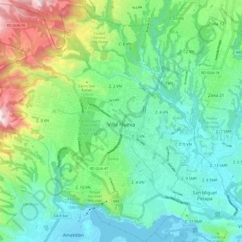
Name: Villa Nueva City topographic map, elevation, terrain.
Location: Villa Nueva City, Guatemala Department, 01064, Guatemala (14.47582 -90.66364 14.58891 -90.55125)
Average elevation: 4,701 ft
Minimum elevation: 3,898 ft
Maximum elevation: 6,877 ft
Make a donation
Gear up for your next adventure:
As an Amazon Associate, this site earns from qualifying purchases at no extra cost to you.
Other topographic maps
Click on a map to view its topography, its elevation and its terrain.
Santa Catarina Pinula
Guatemala > Guatemala Department > Santa Catarina Pinula
Average elevation: 5,187 ft
Colonia Villa de San Juan
Guatemala > Guatemala Department > Guatemala City
Average elevation: 5,036 ft
Make a donation
Gear up for your next adventure:
As an Amazon Associate, this site earns from qualifying purchases at no extra cost to you.
Make a donation
Gear up for your next adventure:
As an Amazon Associate, this site earns from qualifying purchases at no extra cost to you.