
Gelrode topographic map
Interactive map
Click on the map to display elevation.
About this map
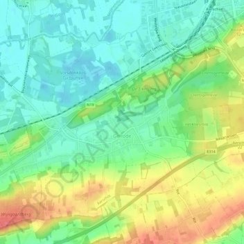
Name: Gelrode topographic map, elevation, terrain.
Location: Gelrode, Aarschot, Leuven, Vlaams-Brabant, Vlaanderen, België (50.95336 4.77398 50.98153 4.82982)
Average elevation: 98 ft
Minimum elevation: 13 ft
Maximum elevation: 236 ft
Other topographic maps
Click on a map to view its topography, its elevation and its terrain.
Aarschot
België > Vlaams-Brabant > Leuven > Aarschot
Aarschot, Leuven, Vlaams-Brabant, Vlaanderen, België
Average elevation: 85 ft
Langdorp
België > Vlaams-Brabant > Leuven > Aarschot
Langdorp, Aarschot, Leuven, Vlaams-Brabant, Vlaanderen, 3201, België
Average elevation: 56 ft