
Sighnaghi topographic map
Interactive map
Click on the map to display elevation.
About this map
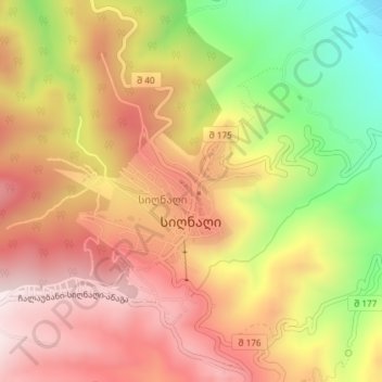
Name: Sighnaghi topographic map, elevation, terrain.
Location: Sighnaghi, Signagi Municipality, Kakheti, 4200, Georgia (41.61546 45.91125 41.62567 45.92879)
Average elevation: 2,211 ft
Minimum elevation: 1,148 ft
Maximum elevation: 2,982 ft
The town has an area of 2.978 ha with 24.3% being residential. Signagi is approximately 113 km southeast of Tbilisi, the capital of Georgia. Signagi District is adjacent, on the town’s east and southwest sides. Signagi is situated in the eastern foothills of the Gombori Range, a watershed between the Iori and Alazani valleys, in a productive agricultural and fruit-growing region. At an elevation of about 790 m above sea level, the town overlooks the Alazani Valley and faces the Greater Caucasus mountains.