
Make a donation
Gear up for your next adventure:
As an Amazon Associate, this site earns from qualifying purchases at no extra cost to you.
Bouzaréah topographic map
Click on the map to display elevation.
Make a donation
Gear up for your next adventure:
As an Amazon Associate, this site earns from qualifying purchases at no extra cost to you.
Bouzaréah
Bouzareah or Bouzaréah (Arabic: بوزريعة, romanized: būzareah) is a suburb of Algiers, Algeria. It had a population of 69,200 people in 1998 and an altitude of over 300 meters AMSL. The city's name is Arabic and means "of the grain" or "from the grain". The embassies of Niger, Oman, and Mauritania are located there.
Make a donation
Gear up for your next adventure:
As an Amazon Associate, this site earns from qualifying purchases at no extra cost to you.
About this map
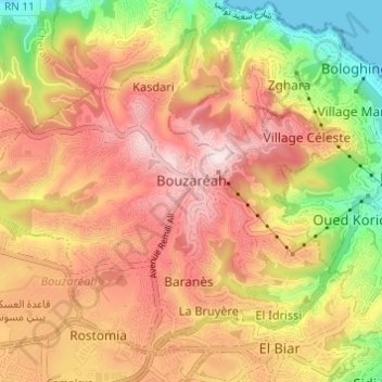
Name: Bouzaréah topographic map, elevation, terrain.
Location: Bouzaréah, Bouzareah District, Algiers, Algeria (36.76842 2.98105 36.80963 3.04189)
Average elevation: 745 ft
Minimum elevation: 0 ft
Maximum elevation: 1,309 ft
Make a donation
Gear up for your next adventure:
As an Amazon Associate, this site earns from qualifying purchases at no extra cost to you.