
Santo Antonino topographic map
Interactive map
Click on the map to display elevation.
About this map
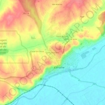
Name: Santo Antonino topographic map, elevation, terrain.
Average elevation: 157 ft
Minimum elevation: 36 ft
Maximum elevation: 289 ft
Other topographic maps
Click on a map to view its topography, its elevation and its terrain.
Ovelhas
Portugal > Santarém > Coruche > São José da Lamarosa
Ovelhas, São José da Lamarosa, Coruche, Santarém, Portugal
Average elevation: 282 ft
Malhada Alta
Malhada Alta, Coruche, Fajarda e Erra, Coruche, Santarém, Portugal
Average elevation: 217 ft
Volta do Vale
Volta do Vale, Couço, Coruche, Santarém, Portugal
Average elevation: 184 ft
Santana do Mato
Portugal > Santarém > Coruche > Santana do Mato
Santana do Mato, Coruche, Santarém, Portugal
Average elevation: 348 ft