
Oca topographic map
Interactive map
Click on the map to display elevation.
About this map
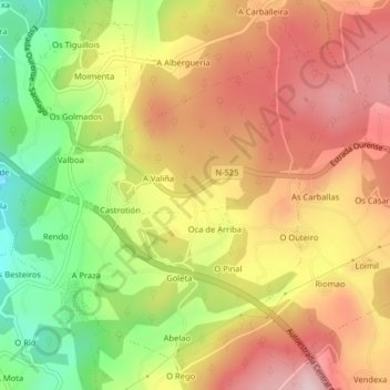
Name: Oca topographic map, elevation, terrain.
Average elevation: 817 ft
Minimum elevation: 289 ft
Maximum elevation: 1,243 ft
Other topographic maps
Click on a map to view its topography, its elevation and its terrain.
Cerdedo-Cotobade
Spain > Galicia > Tabeirós - Terra de Montes
Cerdedo-Cotobade, Tabeirós - Terra de Montes, Pontevedra, Galicia, Spain
Average elevation: 1,880 ft
Cerdedo
Spain > Galicia > Tabeirós - Terra de Montes > Pedre
Cerdedo, Pedre, Cerdedo-Cotobade, Tabeirós - Terra de Montes, Pontevedra, Galicia, Spain
Average elevation: 1,844 ft