
Chengxi District topographic map
Interactive map
Click on the map to display elevation.
About this map
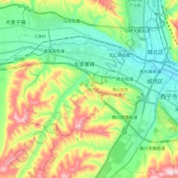
Name: Chengxi District topographic map, elevation, terrain.
Location: Chengxi District, Xining City, Qinghai, 810000, PRC (36.58893 101.62351 36.65515 101.78030)
Average elevation: 7,894 ft
Minimum elevation: 7,293 ft
Maximum elevation: 9,137 ft
Other topographic maps
Click on a map to view its topography, its elevation and its terrain.
Yushu City
Yushu City, Yushu Tibetan Autonomous Prefecture, Qinghai, PRC
Average elevation: 14,731 ft
Gonghe County
Gonghe County, Hainan Tibetan Autonomous Prefecture, Qinghai, PRC
Average elevation: 11,325 ft