
Weisshorn topographic map
Interactive map
Click on the map to display elevation.
About this map
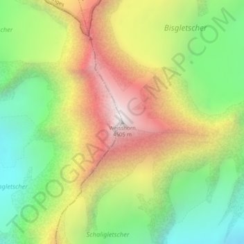
Name: Weisshorn topographic map, elevation, terrain.
Location: Weisshorn, Randa, Visp, Valais/Wallis, 3928, Switzerland (46.10118 7.71609 46.10128 7.71619)
Average elevation: 11,795 ft
Minimum elevation: 9,495 ft
Maximum elevation: 14,642 ft
Other topographic maps
Click on a map to view its topography, its elevation and its terrain.
Nadelhorn
Switzerland > Valais/Wallis > Randa
Nadelhorn, Randa, Visp, Valais/Wallis, 3928, Switzerland
Average elevation: 12,352 ft