
Unterdorf topographic map
Interactive map
Click on the map to display elevation.
About this map
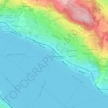
Name: Unterdorf topographic map, elevation, terrain.
Location: Unterdorf, Männedorf, Bezirk Meilen, Zürich, 8708, Schweiz (47.23406 8.66961 47.27406 8.70961)
Average elevation: 1,512 ft
Minimum elevation: 1,319 ft
Maximum elevation: 2,169 ft
Other topographic maps
Click on a map to view its topography, its elevation and its terrain.
Männedorf
Schweiz > Zürich > Bezirk Meilen > Männedorf
Männedorf, Bezirk Meilen, Zürich, 8708, Schweiz
Average elevation: 1,522 ft