
Make a donation
Gear up for your next adventure:
As an Amazon Associate, this site earns from qualifying purchases at no extra cost to you.
Poland topographic map
Click on the map to display elevation.
Make a donation
Gear up for your next adventure:
As an Amazon Associate, this site earns from qualifying purchases at no extra cost to you.
Poland
On July 4, 1876, the Poland Spring House opened atop Ricker's Hill, an elevation of 800 feet (244 m) above sea level with magnificent views to the White Mountains. The hotel would be augmented over the years by architects John Calvin Stevens, Albert Winslow Cobb and Harry Wilkerson. It became a self-contained and exclusive spa, with guards at gatehouses instructed to turn away sightseers. With luxurious accommodations for 450 guests, the hotel attracted the rich and famous. Patrons included Gen. Benjamin Butler, Sen. James G. Blaine, Joan Crawford, Jimmy Durante, Jack Paar and Robert Goulet. But following World War II, the era of grand hotels waned. When the Rickers sold the Poland Spring House, its new owners allowed the sprawling facilities to deteriorate. Apollo Industries purchased the hotel in 1963 and converted it to the largest Women's Job Corps facility in the United States. The Job Corps dormitory was vacated in 1969, and was destroyed by a spectacular fire on July 3, 1975.
Make a donation
Gear up for your next adventure:
As an Amazon Associate, this site earns from qualifying purchases at no extra cost to you.
About this map
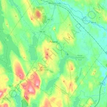
Name: Poland topographic map, elevation, terrain.
Location: Poland, Androscoggin County, Maine, 04274, United States (43.98645 -70.48529 44.10382 -70.28883)
Average elevation: 390 ft
Minimum elevation: 194 ft
Maximum elevation: 866 ft
Androscoggin County trails, hiking, mountain biking, running and outdoor activities
Make a donation
Gear up for your next adventure:
As an Amazon Associate, this site earns from qualifying purchases at no extra cost to you.
Other topographic maps
Click on a map to view its topography, its elevation and its terrain.
East Livermore
United States > Maine > Androscoggin County > Livermore Falls
Average elevation: 364 ft
Make a donation
Gear up for your next adventure:
As an Amazon Associate, this site earns from qualifying purchases at no extra cost to you.