Geolocate

Bath topographic map

Click on the map to display elevation.

About this map
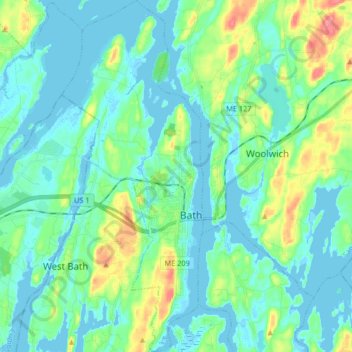
Name: Bath topographic map, elevation, terrain.

Location: Bath, Sagadahoc County, Maine, 04530, United States (43.86663 -69.87466 43.98565 -69.80801)

Average elevation: 52 ft

Minimum elevation: -10 ft

Maximum elevation: 233 ft

Sagadahoc County trails, hiking, mountain biking, running and outdoor activities

Other topographic maps

Click on a map to view its topography, its elevation and its terrain.
Morse Hill

United States > Maine > Sagadahoc County > Phippsburg

Average elevation: 20 ft

Sebasco

United States > Maine > Sagadahoc County

Average elevation: 56 ft

Gear up for your next adventure:

📌Outdoor GPS Map App - Apps and devices for digital topographic navigation
👟Men's Trail Runners - Lightweight footwear for fast-paced exploration and light hiking
🎒Gear Packing Cubes - Organize your backpack efficiently
🌐World Map Poster - Decorative world maps with topographic info
🥾Women's Hiking Boots - Top-rated trail boots with ankle support and superior grip

As an Amazon Associate, this site earns from qualifying purchases at no extra cost to you.