
Stolberg topographic map
Interactive map
Click on the map to display elevation.
About this map
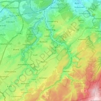
Name: Stolberg topographic map, elevation, terrain.
Average elevation: 873 ft
Minimum elevation: 469 ft
Maximum elevation: 1,647 ft
Other topographic maps
Click on a map to view its topography, its elevation and its terrain.
Montjoie
Allemagne > Rhénanie-du-Nord-Westphalie > Région urbaine d'Aix-la-Chapelle
Montjoie, Région urbaine d'Aix-la-Chapelle, Rhénanie-du-Nord-Westphalie, 52156, Allemagne
Average elevation: 1,808 ft
Loverich
Allemagne > Rhénanie-du-Nord-Westphalie > Région urbaine d'Aix-la-Chapelle > Baesweiler
Loverich, Puffendorf, Baesweiler, Région urbaine d'Aix-la-Chapelle, Rhénanie-du-Nord-Westphalie, Allemagne
Average elevation: 371 ft
Aix-la-Chapelle
Allemagne > Rhénanie-du-Nord-Westphalie > Région urbaine d'Aix-la-Chapelle
Aix-la-Chapelle, Région urbaine d'Aix-la-Chapelle, Rhénanie-du-Nord-Westphalie, Allemagne
Average elevation: 738 ft
Dorff
Allemagne > Rhénanie-du-Nord-Westphalie > Région urbaine d'Aix-la-Chapelle > Stolberg
Dorff, Stolberg, Région urbaine d'Aix-la-Chapelle, Rhénanie-du-Nord-Westphalie, 52223, Allemagne
Average elevation: 833 ft