
The Point topographic map
Interactive map
Click on the map to display elevation.
About this map
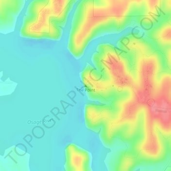
Name: The Point topographic map, elevation, terrain.
Location: The Point, St. Clair County, Missouri, United States (38.09310 -93.58165 38.09320 -93.58155)
Average elevation: 771 ft
Minimum elevation: 679 ft
Maximum elevation: 945 ft
Other topographic maps
Click on a map to view its topography, its elevation and its terrain.
Iconium
United States > Missouri > St. Clair County > Iconium
Iconium, St. Clair County, Missouri, United States
Average elevation: 906 ft