
Make a donation
Gear up for your next adventure:
As an Amazon Associate, this site earns from qualifying purchases at no extra cost to you.
Texcoco de Mora topographic map
Click on the map to display elevation.
Make a donation
Gear up for your next adventure:
As an Amazon Associate, this site earns from qualifying purchases at no extra cost to you.
Texcoco de Mora
Tescoco lies about 25 km east of the centre of Mexico City. Major elevations in the municipality include the Tlaloc Mountain (4,500 meters) the Tetzcutzinco, Moyotepec and Tecuachacho. Most elevations are named after the major community to be found on them. There are also a number of small canyons. Part of the municipality used to be covered by Lake Texcoco, but most of this lake has since been drained. The rivers that fed it, such as the Cozcacuaco, the Chapingo and the San Bernardino still exist.
Make a donation
Gear up for your next adventure:
As an Amazon Associate, this site earns from qualifying purchases at no extra cost to you.
About this map
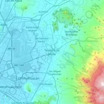
Name: Texcoco de Mora topographic map, elevation, terrain.
Location: Texcoco de Mora, Texcoco, State of Mexico, 56100, Mexico (19.35443 -99.04213 19.67443 -98.72213)
Average elevation: 8,031 ft
Minimum elevation: 7,293 ft
Maximum elevation: 13,520 ft
Make a donation
Gear up for your next adventure:
As an Amazon Associate, this site earns from qualifying purchases at no extra cost to you.