
Lehesten topographic map
Interactive map
Click on the map to display elevation.
About this map
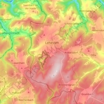
Name: Lehesten topographic map, elevation, terrain.
Average elevation: 2,037 ft
Minimum elevation: 1,234 ft
Maximum elevation: 2,592 ft
Other topographic maps
Click on a map to view its topography, its elevation and its terrain.
Saalfeld/Saale
Deutschland > Thüringen > Landkreis Saalfeld-Rudolstadt
Saalfeld/Saale, Landkreis Saalfeld-Rudolstadt, Thüringen, 07318, Deutschland
Average elevation: 1,447 ft
Schleifenberg
Deutschland > Thüringen > Landkreis Saalfeld-Rudolstadt > Drognitz
Schleifenberg, Drognitz, Kaulsdorf, Landkreis Saalfeld-Rudolstadt, Thüringen, Deutschland
Average elevation: 1,316 ft