Täschhütte topographic map
Interactive map
Click on the map to display elevation.
About this map
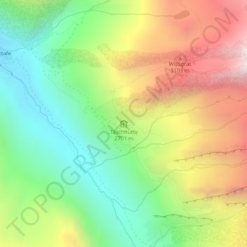
Name: Täschhütte topographic map, elevation, terrain.
Average elevation: 8,845 ft
Minimum elevation: 7,142 ft
Maximum elevation: 11,181 ft

Click on the map to display elevation.
Name: Täschhütte topographic map, elevation, terrain.
Average elevation: 8,845 ft
Minimum elevation: 7,142 ft
Maximum elevation: 11,181 ft