
Unna topographic map
Interactive map
Click on the map to display elevation.
About this map
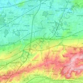
Name: Unna topographic map, elevation, terrain.
Location: Unna, Kreis Unna, Noordrijn-Westfalen, Duitsland (51.49041 7.62875 51.57865 7.84294)
Average elevation: 374 ft
Minimum elevation: 167 ft
Maximum elevation: 801 ft
Other topographic maps
Click on a map to view its topography, its elevation and its terrain.
Schwerte
Duitsland > Noordrijn-Westfalen > Kreis Unna
Schwerte, Kreis Unna, Noordrijn-Westfalen, 58239, Duitsland
Average elevation: 512 ft
Bergkamen
Duitsland > Noordrijn-Westfalen > Kreis Unna
Bergkamen, Kreis Unna, Noordrijn-Westfalen, 59192, Duitsland
Average elevation: 210 ft
Lünen
Duitsland > Noordrijn-Westfalen > Kreis Unna
Lünen, Kreis Unna, Noordrijn-Westfalen, Duitsland
Average elevation: 223 ft