
Saint-Lô topographic map
Interactive map
Click on the map to display elevation.
Saint-Lô
The square of the town hall was completely redeveloped in the 1990s. The city organised a large demonstration on the occasion of the fiftieth anniversary of the Normandy landings. The edges of the Vire were reconfigured with the rehabilitation of the towpath and the creation of a green beach, at the Place du Quai-à-Tangue. A scow was rebuilt and crossed the river, in order to remember former river traffic. In 2004, the rural area of Bois-Jugan was urbanised, with the creation of housing within a framework of preservation of green spaces and a large aquatic centre. Later, the Des Ronchettes water tower was built following an unusual method for the time, since the tank (strongly resembling a flying saucer) was built at the ground level, then raised by a system of jacks, as the rings composing its body were manufactured. As such, its elevation allows a mounting point for telecommunication (mobile phone, WiMAX, and FM radio) networks.
About this map
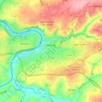
Name: Saint-Lô topographic map, elevation, terrain.
Location: Saint-Lô, Manche, Normandy, Metropolitan France, 50000, France (49.08545 -1.12672 49.13906 -1.03573)
Average elevation: 223 ft
Minimum elevation: 10 ft
Maximum elevation: 459 ft