Geolocate

Cumana topographic map

Click on the map to display elevation.

About this map
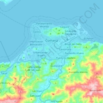
Name: Cumana topographic map, elevation, terrain.

Location: Cumana, Parroquia Santa Inés, Municipio Sucre, Sucre State, 6101, Venezuela (10.37887 -64.24751 10.48415 -64.07987)

Average elevation: 285 ft

Minimum elevation: -7 ft

Maximum elevation: 1,811 ft

Other topographic maps

Click on a map to view its topography, its elevation and its terrain.

Valle de Las Vegas

Venezuela > Sucre State > Municipio Sucre

Average elevation: 2,218 ft

Gear up for your next adventure:

🗺️Topographic Maps - Detailed topo maps for hiking, exploring and outdoor navigation
☀️Outdoor Sunscreen - High protection sunscreen for outdoor activities
🧷Carabiner Set - Durable clips for gear attachment
🧭Pro Hiking Compasses - High-accuracy liquid-filled compasses for topographic orientation
🪶Paracord Bracelet - Survival bracelet with built‑in tools

As an Amazon Associate, this site earns from qualifying purchases at no extra cost to you.