
Lechbruck am See topographic map
Interactive map
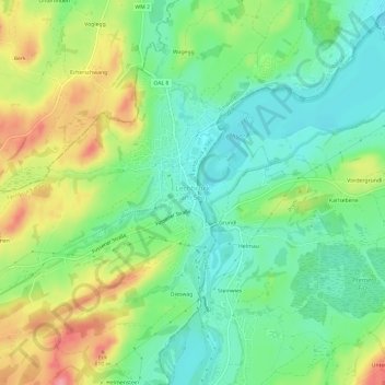
Click on the map to display elevation.
About this map
Name: Lechbruck am See topographic map, elevation, terrain.
Average elevation: 2,477 ft
Minimum elevation: 2,346 ft
Maximum elevation: 2,694 ft
Other topographic maps
Click on a map to view its topography, its elevation and its terrain.
Lech
Deutschland > Bayern > Landkreis Ostallgäu > Lechbruck a.See > Lechbruck am See > Dieswag
Lech, Dieswag, Lechbruck am See, Lechbruck a.See, Steingaden (VGem), Landkreis Ostallgäu, Bayern, 86983, Deutschland
Average elevation: 2,454 ft
Klausmen
Deutschland > Bayern > Landkreis Ostallgäu > Lechbruck a.See > Klausmen
Klausmen, Lechbruck a.See, Landkreis Ostallgäu, Bayern, 86983, Deutschland
Average elevation: 2,559 ft