
Make a donation
Gear up for your next adventure:
As an Amazon Associate, this site earns from qualifying purchases at no extra cost to you.
Olinda topographic map
Click on the map to display elevation.
Make a donation
Gear up for your next adventure:
As an Amazon Associate, this site earns from qualifying purchases at no extra cost to you.
Olinda
The average elevation is 16 m above sea level. The landscapes is made of plains and hills, some of them steep. Olinda is mostly drained by the Paratibe River (55.13% of the territory), with the remainder drained by the Capibaribe River. The municipality is in the Atlantic Forest ecoregion.
Make a donation
Gear up for your next adventure:
As an Amazon Associate, this site earns from qualifying purchases at no extra cost to you.
About this map
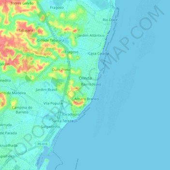
Name: Olinda topographic map, elevation, terrain.
Average elevation: 30 ft
Minimum elevation: -7 ft
Maximum elevation: 210 ft
Make a donation
Gear up for your next adventure:
As an Amazon Associate, this site earns from qualifying purchases at no extra cost to you.
Other topographic maps
Click on a map to view its topography, its elevation and its terrain.
Praça Farias Neves
Brazil > Pernambuco > Região Metropolitana do Recife > Recife
Average elevation: 72 ft
Ana de Alburquerque
Brazil > Pernambuco > Região Metropolitana do Recife > Igarassu
Average elevation: 56 ft