
Thank you for supporting this site ❤️
Make a donation
Make a donation
Gear up for your next adventure:
As an Amazon Associate, this site earns from qualifying purchases at no extra cost to you.
Gemeinde Umhausen topographic map
Click on the map to display elevation.
Thank you for supporting this site ❤️
Make a donation
Make a donation
Gear up for your next adventure:
As an Amazon Associate, this site earns from qualifying purchases at no extra cost to you.
About this map
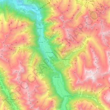
Name: Gemeinde Umhausen topographic map, elevation, terrain.
Location: Gemeinde Umhausen, Bezirk Imst, Tyrol, 6441, Austria (47.07770 10.82521 47.18984 11.06490)
Average elevation: 6,768 ft
Minimum elevation: 2,398 ft
Maximum elevation: 10,666 ft
Thank you for supporting this site ❤️
Make a donation
Make a donation
Gear up for your next adventure:
As an Amazon Associate, this site earns from qualifying purchases at no extra cost to you.