
Make a donation
Gear up for your next adventure:
As an Amazon Associate, this site earns from qualifying purchases at no extra cost to you.
Ourinhos topographic map
Click on the map to display elevation.
Make a donation
Gear up for your next adventure:
As an Amazon Associate, this site earns from qualifying purchases at no extra cost to you.
Ourinhos
Ourinhos is a municipality in the state of São Paulo in Brazil. The population is 114,352 (2020 est.) in an area of 295.82 km2 (114.22 sq mi). The elevation is 483 metres (1,585 ft).
Make a donation
Gear up for your next adventure:
As an Amazon Associate, this site earns from qualifying purchases at no extra cost to you.
About this map
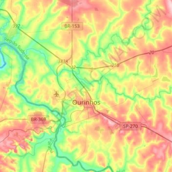
Name: Ourinhos topographic map, elevation, terrain.
Average elevation: 1,473 ft
Minimum elevation: 1,204 ft
Maximum elevation: 1,795 ft
Make a donation
Gear up for your next adventure:
As an Amazon Associate, this site earns from qualifying purchases at no extra cost to you.
Other topographic maps
Click on a map to view its topography, its elevation and its terrain.
Jardim Copacabana
Brazil > São Paulo > Região Metropolitana de São Paulo > São Paulo
Average elevation: 2,598 ft