
Make a donation
Gear up for your next adventure:
As an Amazon Associate, this site earns from qualifying purchases at no extra cost to you.
Wilderswil topographic map
Click on the map to display elevation.
Make a donation
Gear up for your next adventure:
As an Amazon Associate, this site earns from qualifying purchases at no extra cost to you.
Wilderswil
The municipality extends for some 8 km (5.0 mi) from the village, along the west bank of the Lütschine river, and includes the flanks of the mountains that border that valley to the west. Its altitude ranges from some 580 m (1,900 ft), on the Bödeli plain, to 2,413 m (7,917 ft), at the summit of Sulegg. It consists of the villages of Wilderswil, Mülenen and Gsteigallmend.
Make a donation
Gear up for your next adventure:
As an Amazon Associate, this site earns from qualifying purchases at no extra cost to you.
About this map
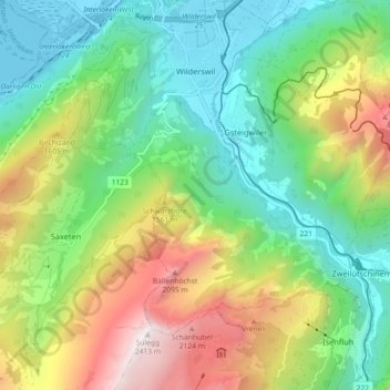
Name: Wilderswil topographic map, elevation, terrain.
Average elevation: 3,930 ft
Minimum elevation: 1,827 ft
Maximum elevation: 7,867 ft
Make a donation
Gear up for your next adventure:
As an Amazon Associate, this site earns from qualifying purchases at no extra cost to you.
Other topographic maps
Click on a map to view its topography, its elevation and its terrain.
Titlis
Switzerland > Bern > Interlaken-Oberhasli administrative district > Innertkirchen
Average elevation: 8,268 ft
Burglauenen
Switzerland > Bern > Interlaken-Oberhasli administrative district > Grindelwald
Average elevation: 4,616 ft
Schilthorn
Switzerland > Bern > Interlaken-Oberhasli administrative district > Lauterbrunnen
Average elevation: 8,054 ft
Brienz
Switzerland > Bern > Interlaken-Oberhasli administrative district > Brienz (BE)
Average elevation: 2,657 ft
Make a donation
Gear up for your next adventure:
As an Amazon Associate, this site earns from qualifying purchases at no extra cost to you.
Ballenberg
Switzerland > Bern > Interlaken-Oberhasli administrative district > Hofstetten bei Brienz > Hofstetten
Average elevation: 2,539 ft
Wellhorn
Switzerland > Bern > Interlaken-Oberhasli administrative district > Schattenhalb
Average elevation: 8,156 ft