
Thank you for supporting this site ❤️
Make a donation
Make a donation
Gear up for your next adventure:
As an Amazon Associate, this site earns from qualifying purchases at no extra cost to you.
Lladurs topographic map
Click on the map to display elevation.
Thank you for supporting this site ❤️
Make a donation
Make a donation
Gear up for your next adventure:
As an Amazon Associate, this site earns from qualifying purchases at no extra cost to you.
About this map
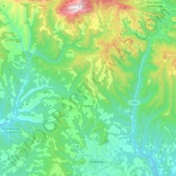
Name: Lladurs topographic map, elevation, terrain.
Location: Lladurs, Solsonès, Lleida, Catalonia, Spain (42.00942 1.36774 42.11179 1.58042)
Average elevation: 2,851 ft
Minimum elevation: 1,713 ft
Maximum elevation: 6,296 ft
Thank you for supporting this site ❤️
Make a donation
Make a donation
Gear up for your next adventure:
As an Amazon Associate, this site earns from qualifying purchases at no extra cost to you.
Other topographic maps
Click on a map to view its topography, its elevation and its terrain.
Sant Llorenç de Morunys
Spain > Catalonia > Solsonès > Sant Llorenç de Morunys > Sant Llorenç de Morunys
Average elevation: 3,369 ft