
La Grande topographic map
Interactive map
Click on the map to display elevation.
About this map
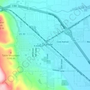
Name: La Grande topographic map, elevation, terrain.
Location: La Grande, Union County, Oregon, 97850, United States (45.30227 -118.11669 45.34612 -118.05289)
Average elevation: 2,910 ft
Minimum elevation: 2,726 ft
Maximum elevation: 3,940 ft
Other topographic maps
Click on a map to view its topography, its elevation and its terrain.
Perry
United States > Oregon > Union County
Perry, Union County, Oregon, United States
Average elevation: 3,648 ft
Blue Mountains
United States > Oregon > Union County
Blue Mountains, Union County, Oregon, 97876, United States
Average elevation: 2,749 ft
Spout Springs
United States > Oregon > Union County
Spout Springs, Union County, Oregon, United States
Average elevation: 5,026 ft
Summerville
United States > Oregon > Union County
Summerville, Union County, Oregon, United States
Average elevation: 2,713 ft
Elk Mountain
United States > Oregon > Union County
Elk Mountain, Union County, Oregon, United States
Average elevation: 4,980 ft