
Rio Abiseo topographic map
Interactive map
Click on the map to display elevation.
About this map
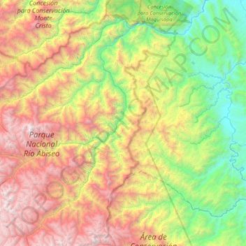
Name: Rio Abiseo topographic map, elevation, terrain.
Average elevation: 6,033 ft
Minimum elevation: 1,024 ft
Maximum elevation: 14,278 ft
Other topographic maps
Click on a map to view its topography, its elevation and its terrain.
Laguna de los Cóndores
Perú > San Martín > Huicungo
Laguna de los Cóndores, Leimebamba - Laguna de los Condores, Huicungo, Mariscal Cáceres, San Martín, Perú
Average elevation: 10,223 ft