
Lefkada topographic map
Click on the map to display elevation.
About this map
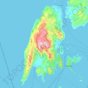
Name: Lefkada topographic map, elevation, terrain.
Average elevation: 364 ft
Minimum elevation: -7 ft
Maximum elevation: 3,806 ft
Other topographic maps
Click on a map to view its topography, its elevation and its terrain.
Athani
Greece > Peloponnese, Western Greece and the Ionian > Lefkada Regional Unit > Municipal Unit of Apollonioi
Average elevation: 1,066 ft
Katomeri
Greece > Peloponnese, Western Greece and the Ionian > Lefkada Regional Unit
Average elevation: 79 ft
Gyra (Anna)
Greece > Peloponnese, Western Greece and the Ionian > Lefkada Regional Unit > Municipal Unit of Lefkada
Average elevation: 0 ft