
Nogent-sur-Seine topographic map
Interactive map
Click on the map to display elevation.
About this map
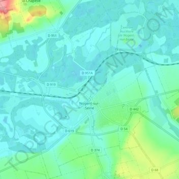
Name: Nogent-sur-Seine topographic map, elevation, terrain.
Average elevation: 240 ft
Minimum elevation: 177 ft
Maximum elevation: 551 ft
Other topographic maps
Click on a map to view its topography, its elevation and its terrain.
Rue du Moulin
France > Grand Est > Aube > Argançon
Rue du Moulin, Argançon, Bar-sur-Aube, Aube, Grand Est, France métropolitaine, 10140, France
Average elevation: 705 ft
Saint-Nicolas-la-Chapelle
Saint-Nicolas-la-Chapelle, Nogent-sur-Seine, Aube, Grand Est, France métropolitaine, 10400, France
Average elevation: 299 ft
Voie des Brebis
France > Grand Est > Aube > Cussangy
Voie des Brebis, Cussangy, Troyes, Aube, Grand Est, France métropolitaine, 10210, France
Average elevation: 614 ft
Rigny-le-Ferron
Rigny-le-Ferron, Troyes, Aube, Grand Est, France métropolitaine, 10160, France
Average elevation: 551 ft
Arrentières
Arrentières, Bar-sur-Aube, Aube, Grand Est, France métropolitaine, 10200, France
Average elevation: 879 ft
Le Village
France > Grand Est > Aube > Fouchères
Le Village, Fouchères, Troyes, Aube, Grand Est, France métropolitaine, 10260, France
Average elevation: 495 ft
Mesnil-Saint-Père
Mesnil-Saint-Père, Troyes, Aube, Grand Est, France métropolitaine, 10140, France
Average elevation: 459 ft
Lusigny-sur-Barse
Lusigny-sur-Barse, Troyes, Aube, Grand Est, France métropolitaine, 10270, France
Average elevation: 420 ft
Landreville
France > Grand Est > Aube > Landreville > Landreville
Landreville, Troyes, Aube, Grand Est, France métropolitaine, 10110, France
Average elevation: 719 ft
Mailly-le-Camp
Mailly-le-Camp, Troyes, Aube, Grand Est, France métropolitaine, 10230, France
Average elevation: 502 ft
Landreville
Landreville, Troyes, Aube, Grand Est, France métropolitaine, 10110, France
Average elevation: 761 ft