
les Bois topographic map
Interactive map
Click on the map to display elevation.
About this map
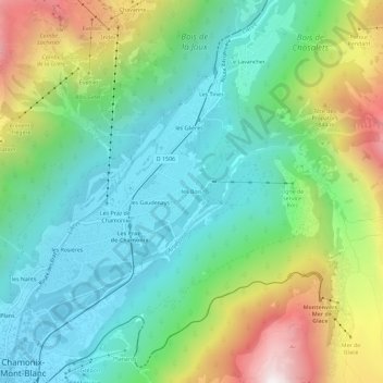
Name: les Bois topographic map, elevation, terrain.
Average elevation: 4,783 ft
Minimum elevation: 3,406 ft
Maximum elevation: 7,802 ft
Other topographic maps
Click on a map to view its topography, its elevation and its terrain.
Le Tour
France > Auvergne-Rhône-Alpes > Haute-Savoie > Chamonix-Mont-Blanc
Le Tour, Chamonix-Mont-Blanc, Bonneville, Haute-Savoie, Auvergne-Rhône-Alpes, France métropolitaine, 74400, France
Average elevation: 5,942 ft