
Carcavelos topographic map
Interactive map
Click on the map to display elevation.
About this map
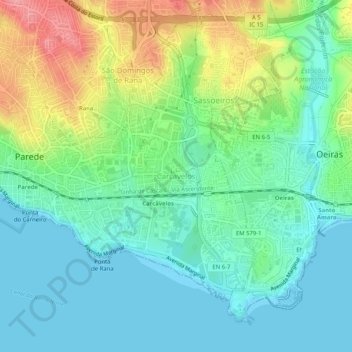
Name: Carcavelos topographic map, elevation, terrain.
Location: Carcavelos, Cascais, Lisboa, 2775-595, Portugal (38.67009 -9.35468 38.71009 -9.31468)
Average elevation: 102 ft
Minimum elevation: 0 ft
Maximum elevation: 338 ft
Other topographic maps
Click on a map to view its topography, its elevation and its terrain.
Carrascal de Manique
Portugal > Lisboa > Cascais > São Domingos de Rana
Carrascal de Manique, São Domingos de Rana, Cascais, Lisboa, Portugal
Average elevation: 390 ft