
Reiskirchen topographic map
Interactive map
Click on the map to display elevation.
About this map
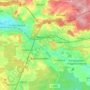
Name: Reiskirchen topographic map, elevation, terrain.
Location: Reiskirchen, Landkreis Gießen, Hessen, 35447, Deutschland (50.54742 8.80217 50.63180 8.92490)
Average elevation: 801 ft
Minimum elevation: 584 ft
Maximum elevation: 1,132 ft
Die Statistisch-topographisch-historische Beschreibung des Großherzogtums Hessen berichtet 1830 über das Busecker Tal:
Other topographic maps
Click on a map to view its topography, its elevation and its terrain.
Gießen
Deutschland > Hessen > Landkreis Gießen
Gießen, Landkreis Gießen, Hessen, Deutschland
Average elevation: 669 ft