
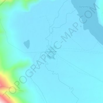
Булункул topographic map
Interactive map
Click on the map to display elevation.
About this map
Name: Булункул topographic map, elevation, terrain.
Average elevation: 12,385 ft
Minimum elevation: 12,264 ft
Maximum elevation: 13,780 ft
Other topographic maps
Click on a map to view its topography, its elevation and its terrain.
Памир
Tadschikistan > Autonome Provinz Berg-Badachschan > Bezirk Murghob
Памир, Bezirk Murghob, Autonome Provinz Berg-Badachschan, Tadschikistan
Average elevation: 20,850 ft
Маркансу
Tadschikistan > Autonome Provinz Berg-Badachschan > Bezirk Murghob
Маркансу, Bezirk Murghob, Autonome Provinz Berg-Badachschan, Tadschikistan
Average elevation: 14,150 ft
Pik Lenin
Tadschikistan > Autonome Provinz Berg-Badachschan > Bezirk Murghob
Pik Lenin, Bezirk Murghob, Autonome Provinz Berg-Badachschan, Tadschikistan
Average elevation: 21,535 ft
Харгуш
Tadschikistan > Autonome Provinz Berg-Badachschan > Bezirk Murghob
Харгуш, Bezirk Murghob, Autonome Provinz Berg-Badachschan, Tadschikistan
Average elevation: 13,094 ft
Murghab
Tadschikistan > Autonome Provinz Berg-Badachschan > Bezirk Murghob
Murghab, Bezirk Murghob, Autonome Provinz Berg-Badachschan, 736600, Tadschikistan
Average elevation: 12,457 ft